Friday, February 14, 2014

Madera Canyon Feb 8, 2014


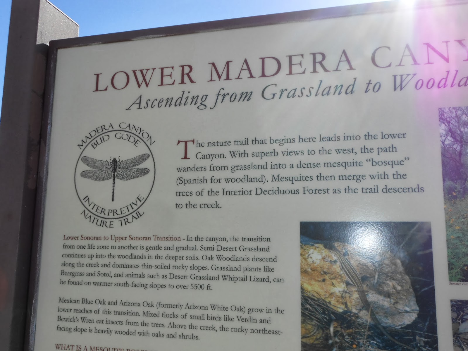
Madera Canyon is located in the Coronado National Forest, 12 miles east of Green Valley.    We’ve been gazing at those beautiful mountains for days.  So, off we went to check out Madera Canyon.   It is a short drive and our Senior Park Passes got us in without paying the $10.00 entrance fee.   ( Forest Service funding ended in 1987.  This is the second wildlife area (Coronado State Park, north of Tucson is the first) that a group of “friends” have organized to keep it open.  The entrance fee keeps the roads accessible.  The Friends of Madera Canyon contribute 5000 to 6000 volunteer hours annually.
We drove the paved road up the mountain to the end, as close as we could get without hiking to Mt Wrightson.  It would take 10.8 mile hike one way to get there.  Instead we walked a short portion of the 9 mile Old Baldy Trail. (Although our Esperanza walking path is a good start, we are not ready for anything vigorous.)The views of the mountains that tower over us are so amazing to this Midwestern.  Our prairie lands have their own specialness, but these mountains are forever changing in color and definition.  You can see rock bluffs as the dirt has been worn away by wind and rain and probably snow at this height.


Madera Canyon experienced a fire in 2005 which was described as burning in a "mosaic pattern" meaning that the fire skipped around the mountain side.   The charred bark on this tree indicates it was in the fire but not totally damaged.  So, I guess this is how a forest repairs itself.  I was wondering about that after seeing the totally burned out mountains in the Gila Range in New Mexico (- see Jan 28-41 blog) 


Looking up


Looking down at valley


Grateful for the handrails on the path down!!


The park maintains teaching areas for school children and adult field trips.


We did not see any. ( Thank you Lord!!)


We stopped at Bog Springs Trail head to have our picnic lunch.  As you can tell this is a forested area.  Not many cacti.  The temperature was an invigorating 60 degrees, so we thought we’d try some of the Bog Springs trail.  After all, I could not imagine any swamp like areas up here on this mountain.  


No matter how close we get, there's always more mountain.


 We thought .4 mile didn’t sound too bad.  However, it proved to be quite rocky and quite an incline, so we came back down.  There is a road that leads to the Bog Springs camp Ground.  We’ll try that next time just to see if there why the trail is named Bog Spring.

Leaving the easiest to last, we walked some of the paved wheelchair accessible path.  


We found this very old grave site off to the side of the path, but there is no printed information about it.  The inscription said,"Sister" and "Brother" and we could not read the rest.  It was very weather worn.  We’ll have to ask one of the docents about it.
 This large rock formation is called Elephant Head.  There is a hiking path to it, but not for us today


Even though we are at the lowest trail in Madera Canyon, the valley below is still very far away.  We agree to come back once a week.  This is a beautiful, quiet place.  And, they have a gift shop!
Time to go home and check for sun burn.     


Thursday, February 13, 2014

Esperanza Estates Walking Trail

Here are some pictures of the walking trail that encircles this complex.  It was developed by the association here and has some lovely views of desert plants and Santa Rita Mountains.
Desert landscaping... cactus and rocks and pottery.


Nice little bridge.  I can't really see how water will get to this path, but then I've never been here in rainy season.

Mesquite Park

Santa Rita Mountains
Most paths are level, but this one angles down toward the wash.  The mountains are so beautiful.

This is the second half of the 1 and 1/2 mile trail.


Wishing Well Park
 

The path that went down, must of course, go back up.  It's not too hard, we just have to slow down till we get our huffing and puffing under control. 
Bridge Park

Whigham Wash


Back home in the side patio.  It has been in the 70s, but we have a nice breeze here. Long sleeves are needed in the shade.  And everyone needs a serious sun hat! 

By now, you have a good understanding of the desert landscape.  Remember, this is Arizona's winter view.  The desert wild flowers will really add a different view.  It has snowed the last 3 years we've been here, but this year it looks like all the snow storms went way north ( Polar Vortex, you know).  So we'll have to see what moisture happened and if the wild flowers have a chance.    


Thursday, February 6, 2014

Feb 1, 2014    941 Calle del Regalo, Esperanza Estates, Green Valley, AZ 85614
We unloaded our winter to summer clothes and groceries and are settling in.  Here are a few pictures of the outside.  We chose this unit because the patios extend from the front, side and back which will give us access to sunshine anytime of the day.
Front

Screen enclosed side porch on the side

Back patio

Back patio 

Side 

Living room

Finally, time to relax!!

Jan 28 - Jan 31, 2014
This is last year's snowy picture of our neighborhood.  We were so discouraged about our long, bitter. brutally cold weather that we didn't bother to record what the snow looked like this year. Just add more snow, more bone chilling wind, and prolonged gray skies, and that would have been the 2014 view.
Leaving+Kenosha+for+AZ+2-4-2013.jpg (1600×1200)
We played tha game of.  "How far south will we have to drive to get above freezing?".   When we crossed the Oklahome/Texas line, the temperature finally nudged above 32.  Dodging winter storms that race through the midwest has always been our plan.  Since we delayed leaving on Monday due to 35 mile per hour wind gusts in Wisconsin and Illinois, we did not run in to any percipitation until New Mexico, and then just sprinkles.  However, the strong wnd gusts followed us all the way to Green Valley, Arizona.

 Jan 31, 2014
We detoured off our usual routes( I-94 to I-55 to I -44 to I-40 to I-25 to I-10) and drove through the Gila Mountain State Park in New Mexico( Rte 152).  It will be a favorite from now on.  This "flat lander" is always amazed at the high desert into mountain views.


Seeing any water in a stream is always a surprise


And then we're high enough for forest

Not sure when this fire occurred.  I wonder how long it will take to be re forested.

Picnic, anyone?  It is 43 degrees at this elevation, but the mountains block the wind.

And then, this massive scar on the land.  The southwest has its wonderful wealth of minerals and these mountain reducing mines can be seen many places.  It was such a shock after seeing the beautiful forests.  I am very thankful we have saved state and national parks or many views would look like this   

This is what is under the mountains.  Lots of copper but how can this ever be re forested??